Generic Geometric Transformations
imwarp
workflowGeometric transformations map pixel coordinates in the output image to coordinates in the input image. The mapping process then interpolates the value of output pixels from the input image.
Use these functions to perform general 2-D, 3-D, and N-D geometric
transformations. To perform a 2-D or 3-D geometric transformation, first create
a geometric transformation object that stores information about the
transformation. Then, pass the image to be transformed and the geometric
transformation object to the imwarp function.
Functions
Topics
Geometric Transformation
- 2-D and 3-D Geometric Transformation Process Overview
To perform a general geometric transformation of a 2-D or 3-D image, first define the parameters of the transformation, then warp the image. - Matrix Representation of Geometric Transformations
Represent geometric transformations, such as translation, scaling, rotation, and reflection, using matrices whose elements represent parameters of the transformations. - Migrate Geometric Transformations to Premultiply Convention
Starting in R2022b, functions that create and perform geometric transformations were updated to use a premultiply matrix convention. - N-Dimensional Spatial Transformations
You can create custom geometric transformations to process images of arbitrary dimension, or to change the dimensionality of the output image from the input image. - Specify Fill Values in Geometric Transformation Output
Specify the color of blank space in the image after a geometric transformation.
Spatial Referencing
- Image Coordinate Systems
Learn how image locations are expressed using discrete pixel indices and continuous spatial coordinates. - Define World Coordinate System of Image
Spatial referencing objects encode the relationship between the image extent in intrinsic coordinates, the image extent in world coordinates, and the image resolution. - Shift X- and Y-Coordinate Range of Displayed Image
This example shows how to specify a nondefault world coordinate system by changing theXDataandYDataproperties of a displayed image.
Featured Examples
Create Composite 2-D Affine Transformations
Combine multiple affine geometric transformations using matrix multiplication.
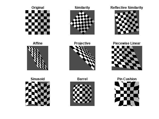
Create a Gallery of Transformed Images
Warp a test image using several built-in and custom geometric transformations, including affine, projective, polynomial, piecewise linear, sinusoidal, barrel, and pin-cushion transformations.

Perform Simple 2-D Translation Transformation
Shift an image vertically and horizontally, and use spatial referencing information to display the original image and the translated image from the same perspective.