occupancyMap3D
Create 3-D occupancy map
Description
The occupancyMap3D object stores a 3-D map and map information.
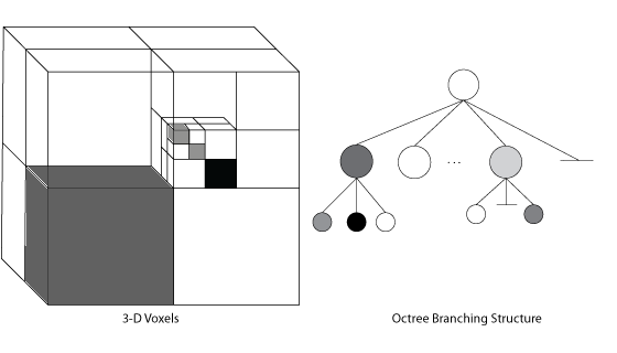
The map is stored as probabilistic values in an octree data
structure. The class handles arbitrary environments and expands its size
dynamically based on observation inputs. You can add observations as point clouds or as
specific xyz-locations. These observations update the probability
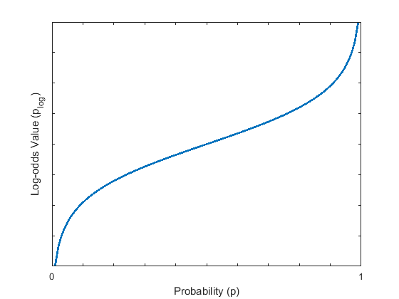
values. Probabilistic values represent the occupancy of locations. The octree data
structure trims data appropriately to remain efficient both in memory and on
disk.
Creation
Description
omap = occupancyMap3D
omap = occupancyMap3D(res)Resolution property.
omap = occupancyMap3D(res,Name,Value)"FreeThreshold",0.25 sets the threshold to consider
cells obstacle-free as a probability value of 0.25.
Properties
Object Functions
checkOccupancy | Check if locations are free or occupied |
getOccupancy | Get occupancy probability of locations |
inflate | Inflate each occupied location |
insertPointCloud | Insert 3-D points or point cloud observation into map |
rayIntersection | Find intersection points of rays and occupied map cells |
setOccupancy | Set occupancy probability of locations |
show | Display 3-D occupancy map |
updateOccupancy | Update occupancy probability at locations |
Examples
Algorithms
References
[1] Hornung, Armin, Kai M. Wurm, Maren Bennewitz, Cyrill Stachniss, and Wolfram Burgard. "OctoMap: an efficient probabilistic 3D mapping framework based on octrees." Autonomous Robots 34, no. 3 (April 2013): 189–206. https://doi.org/10.1007/s10514-012-9321-0.
Extended Capabilities
Version History
Introduced in R2019b
See Also
Objects
Functions
checkMapCollision|insertPointCloud|inflate|setOccupancy|show|rosReadOccupancyMap3D(ROS Toolbox)
![Figure contains an axes object. The axes object with title Occupancy Map, xlabel X [meters], ylabel Y [meters] contains an object of type patch.](../../examples/nav/win64/Create3DOccupancyMapAndInflatePointsExample_01.png)
![Figure contains an axes object. The axes object with title Occupancy Map, xlabel X [meters], ylabel Y [meters] contains an object of type patch.](../../examples/nav/win64/Create3DOccupancyMapAndInflatePointsExample_02.png)
![Figure contains an axes object. The axes object with title Occupancy Map, xlabel X [meters], ylabel Y [meters] contains an object of type patch.](../../examples/nav/win64/Create3DOccupancyMapAndInflatePointsExample_03.png)

