Main Content

landSurface

Add land surface to radar scenario

Since R2022a

    Description

    example

    srf = landSurface(scene) adds a LandSurface object srf to the radar scenario radarScenario scene.

    srf = landSurface(scene,Name=Value) adds a land surface object with the specified property Name set to the specified Value. You can specify additional name-value pair arguments in any order as (Name1=Value1,...,NameN=ValueN).

    Examples

    collapse all

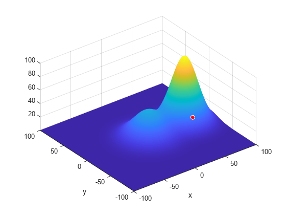
    Create a surface with two hills. Plot the surface on a 200-by-200 meter grid with grid points one meter apart. Add the surface to a radar scenario. Assume the surface has a radar reflectivity defined by a constant gamma model.

    [x,y] = meshgrid(linspace(-100,100,201));
    ht1 = 40*exp(-(x.^2 + y.^2)/30^2);
    ht2 = 100*exp(-((x-60).^2 + y.^2)/25^2);
    ht = ht1 + ht2;
    p = surfc(x(1,:),y(:,1),ht);
    axis equal
    axis tight
    shading interp
    simTime = 3;
    scene = radarScenario(UpdateRate = 1, ...
        IsEarthCentered = false,StopTime = simTime);
    gammaDB = surfacegamma('Flatland');
    refl = surfaceReflectivityLand(Model = 'ConstantGamma',Gamma = gammaDB);
    srf = landSurface(scene,RadarReflectivity = refl, ...
        Terrain = ht,Boundary = [-100,100;-100,100]);

    Use surface manager to identify the surface.

    scene.SurfaceManager
    ans = 
      SurfaceManager with properties:
    
        EnableMultipath: 0
           UseOcclusion: 1
               Surfaces: [1x1 radar.scenario.LandSurface]
    
    
    scene.SurfaceManager.Surfaces
    ans = 
      LandSurface with properties:
    
            RadarReflectivity: [1x1 surfaceReflectivityLand]
        ReflectionCoefficient: [1x1 radar.scenario.SurfaceReflectionCoefficient]
              ReflectivityMap: 1
              ReferenceHeight: 0
                     Boundary: [2x2 double]
                      Terrain: [201x201 double]


    Obtain and plot the height of the surface at the point (50,-30).

    xt = 50;
    yt = -30;
    htx = height(srf,[xt,yt])
    htx = 21.1046
    
    hold on
    plot3(xt,yt,htx+5,'ow','MarkerFaceColor','r')
    xlabel('x')
    ylabel('y')
    hold off

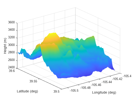
    Create a radar scenario and specify its IsEarthCentered property as true to use DTED file.

    scene = radarScenario(IsEarthCentered = true);

    Model the reflectivity as a constant gamma surface.

    refl = surfaceReflectivityLand(Model = 'ConstantGamma',Gamma = -20);

    Add a 0.1-by-0.1 degree land surface derived from a DTED file.

    bdry = [39.5 39.6;-105.51 -105.41];
    srf = landSurface(scene,Terrain = 'n39_w106_3arc_v2.dt1', ...
        Boundary = bdry,RadarReflectivity = refl)
    srf = 
      LandSurface with properties:
    
            RadarReflectivity: [1x1 surfaceReflectivityLand]
        ReflectionCoefficient: [1x1 radar.scenario.SurfaceReflectionCoefficient]
              ReflectivityMap: 1
              ReferenceHeight: 0
                     Boundary: [2x2 double]
                      Terrain: 'n39_w106_3arc_v2.dt1'
    
    
    mgr = scene.SurfaceManager
    mgr = 
      SurfaceManager with properties:
    
        EnableMultipath: 0
           UseOcclusion: 1
               Surfaces: [1x1 radar.scenario.LandSurface]


    Plot the surface height.

    x = linspace(srf.Boundary(2,1),srf.Boundary(2,2),201);
    y = linspace(srf.Boundary(1,1),srf.Boundary(1,2),201);
    [X,Y] = meshgrid(x,y);
    X1 = X(:)';
    Y1 = Y(:)';
    H = height(srf,[Y1;X1]);
    H = reshape(H,length(x),length(y));
    surf(x,y,H)
    shading interp
    ylabel('Latitude (deg)')
    xlabel('Longitude (deg)')
    zlabel('Height (m)')

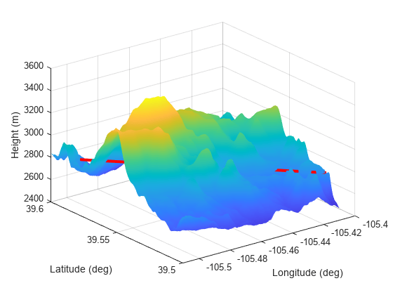
    Create a radar scenario and specify set the IsEarthCentered property as true to obtain the terrain from a DTED file.

    scene = radarScenario(IsEarthCentered = true);

    Model the reflectivity as a constant gamma surface.

    refl = surfaceReflectivityLand(Model = 'ConstantGamma',Gamma = -20);

    Add a 0.1-by-0.1 degree land surface derived from a DTED file.

    bdry = [39.5 39.6;-105.51 -105.41];
    srf = landSurface(scene,Terrain = 'n39_w106_3arc_v2.dt1', ...
        Boundary = bdry,RadarReflectivity = refl);

    Verify that occlusion is turned on.

    mgr = scene.SurfaceManager
    mgr = 
      SurfaceManager with properties:
    
        EnableMultipath: 0
           UseOcclusion: 1
               Surfaces: [1x1 radar.scenario.LandSurface]


    Plot the surface height.

    x = linspace(srf.Boundary(2,1),srf.Boundary(2,2),201);
    y = linspace(srf.Boundary(1,1),srf.Boundary(1,2),201);
    [X,Y] = meshgrid(x,y);
    X1 = X(:)';
    Y1 = Y(:)';
    H = height(srf,[Y1;X1]);
    H = reshape(H,length(x),length(y));
    surf(x,y,H)
    shading interp
    ylabel('Latitude (deg)')
    xlabel('Longitude (deg)')
    zlabel('Height (m)')
    hold on

    Test for occlusion.

    ht1 = height(srf,[39.59 -105.5])
    ht1 = 2.7962e+03
    
    ht2 = height(srf,[39.51 -105.41])
    ht2 = 2.7718e+03
    
    occlusion(srf,[39.59 -105.5 ht1],[39.51 -105.41 ht2])
    ans = logical
       1


    The points are occluded. The line between the two points passes through the surface as shown.

    plot3([-105.5 -105.41],[39.59 39.51], [ht1 ht2],'r','LineWidth',3)

    Input Arguments

    collapse all

    Radar scenario, specified as a radarScenario object.

    Name-Value Arguments

    Specify optional pairs of arguments as Name1=Value1,...,NameN=ValueN, where Name is the argument name and Value is the corresponding value. Name-value arguments must appear after other arguments, but the order of the pairs does not matter.

    Before R2021a, use commas to separate each name and value, and enclose Name in quotes.

    Example: surface = landSurface(scene,Boundary=[-100,100,-100,100])

    Radar reflectivity object of surface, specified as a surfaceReflectivityLand or surfaceReflectivityCustom System object™ for the normalized radar cross section (NRCS) of the surface. Defaults to a surfaceReflectivityLand object using a Barton land model and flatland land type.

    Example: surfaceReflectivityLand(Model="GIT",LandType="Soil",SurfaceHeightStandardDeviation=1)

    This property contains a grid of reflectivity type values corresponding to vertices of the surface height data. If any terrain or a spectral model is present, ReflectivityMap must be a matrix of the same size as the domain of that data. Otherwise it must be scalar. Each element is an index into the third dimension of the Reflectivity property of the surfaceReflectivityCustom object.

    Dependencies

    To enable this property, set the RadarReflectivity property to a surfaceReflectivityCustom object.

    Data Types: double

    Surface reflection coefficient for use in multipath calculations, specified either as a SurfaceReflectionCoefficient object that defines the reflectivity model or as scalar with a value between -1 and 1. The default value is a SurfaceReflectionCoefficient object containing the earthSurfacePermittivity model of a dry sandy loam for a flat, non-vegetated surface. Note, by default, the reflectionCoefficient object function is called internally on the SurfaceReflectionCoefficient object to calculate the cumulative reflection coefficient value during multipath modeling if the EnableMultipath property is set to true in SurfaceManager.

    Complex Number Support: Yes

    Reference height of surface height data, specified as a scalar. Surface heights are relative to the reference height. Units are in meters.

    Data Types: double

    Bounding rectangle of the surface, specified as a 2-by-2 matrix of real values. The bounding rectangle is defined by two two-dimensional points in either Cartesian or geodetic scenario coordinates. When the IsEarthCentered property of the radarScenario object is specified as:

    • false — Scenario coordinates are Cartesian. Specify the bounding rectangle [MinX, MaxX, MinY MaxY], as Cartesian coordinates in the reference frame of the scenario, where MinX < MaxX, and MinY < MaxY.

    • true — Scenario coordinates are geodetic. Specify the bounding rectangle as [StartLat, EndLat, StartLon EndLon] where StartLat and EndLat are the minimum and maximum latitudes of the geodetic frames. StartLat and EndLat must lie in the interval [–90,90] where StartLat < EndLat.

      Specify StartLon and EndLon as the minimum and maximum longitudes of the geodetic frame. StartLon and EndLon must lie in the interval [–180,180]. If EndLon < StartLon, the object wraps EndLon to StartLon + 360°. Units are in degrees.

    Data Types: double

    Terrain data of the surface, specified as an M-by-N real-valued matrix or a string containing a Digital Terrain Elevation Data (DTED) file name. Terrain data consists of land height as a function of geo-position and is assumed to be referenced to the WGS84 ellipsoidal model. When a DTED filename is provided, it is expected that the data in the DTED file is referenced to the EGM96 geoid model.

    • M-by-N real-valued matrix — The matrix values represent the height data of an area defined by the Boundary property of the surface object. The domain can be a global Cartesian frame in meters or a geodetic grid with units of degrees. The object extends the height data in the matrix to the area. The object automatically fills heights of unspecified points using linear interpolation. M or N must be greater than or equal to 3.

    • DTED file name — To use this option, you must specify the IsEarthCentered property of the radar scenario as true. In this case, the function uses the DTED file to specify the terrain heights for an area defined by the Boundary property of the ground surface object. Also, the object automatically fills unspecified data in the DTED file using linear interpolation.

    Height values here are relative to the ReferenceHeight property.

    Data Types: double | string | char

    Output Arguments

    collapse all

    Land surface, returned as a LandSurface object.

    Version History

    Introduced in R2022a