filterm
Filter latitudes and longitudes based on underlying data grid
Description
Examples
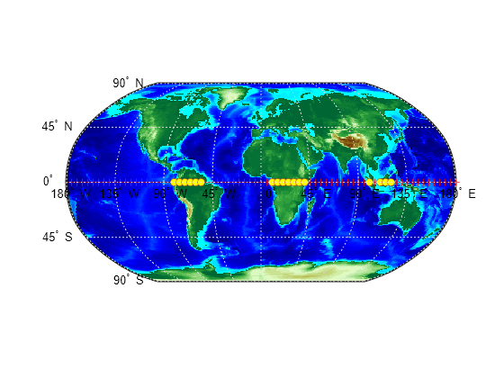
Display points along the equator that are above sea level.
First, load elevation raster data and a geographic cells reference object. The raster contains terrain heights relative to mean sea level. Then, specify the coordinates of evenly spaced points along the equator.
load topo60c
lon = (0:5:360)';
lat = zeros(size(lon));
Create a logical array representing the terrain above sea level. Then, filter the points along the equator to include only the elements that contain true.
topoASL = topo60c > 0;
[newlat,newlon] = filterm(lat,lon,topoASL,topo60cR,1);
Create a world map and display the elevation data. Display the all of the points along the equator using red markers. Then, display the points that are above sea level using yellow circles.
worldmap world
geoshow(topo60c,topo60cR,'DisplayType','texturemap')
demcmap(topo60c)
geoshow(lat,lon,'DisplayType','point','MarkerEdgeColor','r')
geoshow(newlat,newlon,'DisplayType','point','Marker','o',...
    'MarkerFaceColor','y')

Input Arguments
Latitude values, specified as a numeric array.
Data Types: single | double
Longitude values, specified as a numeric array.
Data Types: single | double
Filter, specified as a numeric array.
Data Types: single | double | int8 | int16 | int32 | int64 | uint8 | uint16 | uint32 | uint64 | logical
Spatial referencing information, specified as a GeographicCellsReference object or a GeographicPostingsReference object. The RasterSize
property of R must be consistent with
size(Z).
Data Types: double
Allowed values, specified as a numeric array or character vector.
Data Types: single | double | int8 | int16 | int32 | int64 | uint8 | uint16 | uint32 | uint64 | logical | char
Output Arguments
Latitudes of filtered points, returned as a numeric array.
Longitudes of filtered points, returned as a numeric array.
Indices of filtered points, returned as a numeric array.
Version History
Introduced before R2006aThe filterm function does not accept referencing vectors or
referencing matrices as input. Use a geographic raster reference object, specified as a
GeographicCellsReference or GeographicPostingsReference object, as input instead. Reference objects have
several advantages over referencing vectors and referencing matrices.
Unlike referencing vectors and referencing matrices, reference objects have properties that document the size of the associated raster, its geographic limits, and the direction of its rows and columns.
You can manipulate the limits of geographic rasters associated with reference objects using the
geocropfunction.You can manipulate the size and resolution of geographic rasters associated with reference objects using the
georesizefunction.
To update your code, create a geographic reference object.
Create a geographic reference object for a raster of cells by using the
georefcellsfunction.Create a geographic reference object for a raster of regularly posted samples by using the
georefpostingsfunction.Convert from a referencing vector to a geographic reference object by using the
refvecToGeoRasterReferencefunction.Convert from a referencing matrix to a geographic reference object by using the
refmatToGeoRasterReferencefunction.
Once you have created a reference object, replace uses of the referencing vector or referencing matrix in your code with the reference object.
When you specify a referencing vector or referencing matrix as input, the
filterm function issues a warning that it will not accept referencing
vectors or referencing matrices as input in a future release.
MATLAB Command
You clicked a link that corresponds to this MATLAB command:
Run the command by entering it in the MATLAB Command Window. Web browsers do not support MATLAB commands.
Website auswählen
Wählen Sie eine Website aus, um übersetzte Inhalte (sofern verfügbar) sowie lokale Veranstaltungen und Angebote anzuzeigen. Auf der Grundlage Ihres Standorts empfehlen wir Ihnen die folgende Auswahl: .
Sie können auch eine Website aus der folgenden Liste auswählen:
So erhalten Sie die bestmögliche Leistung auf der Website
Wählen Sie für die bestmögliche Website-Leistung die Website für China (auf Chinesisch oder Englisch). Andere landesspezifische Websites von MathWorks sind für Besuche von Ihrem Standort aus nicht optimiert.
Amerika
- América Latina (Español)
- Canada (English)
- United States (English)
Europa
- Belgium (English)
- Denmark (English)
- Deutschland (Deutsch)
- España (Español)
- Finland (English)
- France (Français)
- Ireland (English)
- Italia (Italiano)
- Luxembourg (English)
- Netherlands (English)
- Norway (English)
- Österreich (Deutsch)
- Portugal (English)
- Sweden (English)
- Switzerland
- United Kingdom (English)