Hauptinhalt

roadSurface

Extract road surface information from point cloud data using road reference line

Since R2025b

Description

The roadSurface object extracts road surface information from point cloud data. The object stores the surface information of a road specified using a road reference line and the road width from the road reference line.

Creation

Description

rsObj = roadSurface(roadData,roadRefLine,roadWidthFromRefLine,gridResolution) creates a roadSurface object, rsObj, for a road in the point cloud data roadData. The roadSurface object contains the surface information of the road, specified by the road reference line roadRefLine and road width from the reference line roadWidthFromRefLine, with a grid resolution gridResolution.

example

rsObj = roadSurface(filename) creates a road surface object from the specified ASAM OpenCRG® file filename.

rsObj = roadSurface(___,Name=Value) sets writable properties using one or more name-value arguments, in addition to any combination of input arguments from the previous syntaxes. For example, InterpolationMethod="linear" specifies the linear interpolation method for interpolating the missing point cloud data.

Note

This feature requires the Scenario Builder for Automated Driving Toolbox™ support package. You can install the Scenario Builder for Automated Driving Toolbox support package from the Add-On Explorer. For more information about installing add-ons, see Get and Manage Add-Ons.

example

Input Arguments

expand all

Lidar point cloud data, specified as a pointCloud object or an M-by-3 matrix.

If you specify an M-by-3 matrix, each row specifies the x-, y-, and z-coordinates of a point in the point cloud.

The roadData you specify must contain data for the road you specify using the roadRefLine and roadWidthFromRefLine input arguments.

Road reference line, specified as an N-by-3 matrix, N-by-2 matrix, or a Trajectory object. N is the number of waypoints.

If you specify an N-by-3 matrix, each row represents the x-, y-, and z-coordinates of a waypoint.

If you specify an N-by-2 matrix, each row represents the x- and y-coordinates of a waypoint.

Waypoints are in the world coordinate system in the ENU frame of reference. Units are in meters.

This argument sets the RoadReferenceLine property.

Width of the road from the road reference line, specified as a scalar or a two-element vector of the form [a b]. The values of a and b represent the width of the road from the road reference line on the left and right sides, respectively. Units are in meters.

If you specify a scalar, the value represents the width of the road from the road reference line on each side.

This argument sets the RoadWidthFromRefLine property.

Data Types: double

Grid resolution for representing the road surface, specified as a scalar or a two-element vector of the form [longitudinalResolution lateralResolution]. Units are in meters.

If you specify a scalar, the object uses the same value for both longitudinalResolution and lateralResolution.

This argument sets the LongitudinalResolution and LateralResolution properties.

Data Types: double

ASAM OpenCRG filename, specified as a string scalar or a character vector.

You can specify filename as the absolute or relative path to a file with the .crg extension. For example, if the file myFile.crg is in your current folder, C:\myFolder, you can specify the ASAM OpenCRG file as "myFile.crg" or "C:\myFolder\myFile.crg".

Data Types: string | char

Name-Value Arguments

expand all

Specify optional pairs of arguments as Name1=Value1,...,NameN=ValueN, where Name is the argument name and Value is the corresponding value. Name-value arguments must appear after other arguments, but the order of the pairs does not matter.

Example: roadSurface(roadData,roadRefLine,roadWidthFromRefLine,gridResolution,InterpolationMethod="linear") specifies to use linear interpolation to interpolate the missing point cloud data.

Interpolation method, specified as one of these options.

Interpolation MethodDescriptionContinuity
"nearest"

Nearest neighbor interpolation

Discontinuous
"linear"

Linear interpolation

C0
"natural"

Natural neighbor interpolation

C1 (except at sample points)

The object interpolates the road surface data for missing point cloud values at curved grid locations.

This argument sets the InterpolationMethod property.

Data Types: char | string

Extrapolation method, specified as one of these options.

Extrapolation MethodDescription
"nearest"

Nearest neighbor extrapolation. This method evaluates to the value of the nearest neighbor.

"linear"

Linear extrapolation based on boundary gradients.

"boundary"

Boundary extrapolation. This method extends the values on the interpolation boundary into the extrapolation domain.

"none"

No extrapolation. Any queries outside the convex hull of roadData return NaN.

The object extrapolates the road surface data at curve grid locations outside the convex hull of point cloud data.

This argument sets the ExtrapolationMethod property.

Data Types: char | string

Anchor of the road trajectory, specified as a three-element row vector of the form [latitude longitude altitude]. Units of latitude and longitude are in degrees, and units of altitude are in meters.

The LocalOrigin value defines the anchor of the trajectory of the specified road in the local coordinate system.

For a trajectory created from sensor data other than GPS data, the LocalOrigin value defines the origin of the local Cartesian coordinate system, specified as a three-element row vector of the form [x y z]. Units are in meters.

This argument sets the LocalOrigin property.

Data Types: double

Normalize road elevation values, specified as a logical 1 (true) or 0 (false).

By default, the roadSurface object normalizes the road elevation values with respect to the reference line of the road surface. You can use the normalized ASAM OpenCRG data to import it into an ASAM OpenDRIVE® road network in attached mode. For more information on CRG modes, see the Parameters (RoadRunner) section of the RoadRunner Road CRG Tool.

This argument sets the HasNormalizedElevation property.

Data Types: logical

Show progress bar, specified as a logical 1 (true) or 0 (false). Specify true to display a progress bar for road surface evaluation. Otherwise, specify false.

Output Arguments

expand all

Road surface object, returned as a roadSurface object.

Properties

expand all

This property is read-only after object creation. To set this property, use the roadRefLine argument when calling the roadSurface function.

Road reference line, represented as an N-by-2 matrix, N-by-3 matrix, or a Trajectory object. N is the number of waypoints.

If you specify an N-by-2 matrix, each row represents the x- and y-coordinates of a waypoint.

If you specify an N-by-3 matrix, each row represents the x-, y-, and z-coordinates of a waypoint.

Waypoints are in the world coordinate system in the ENU frame of reference. Units are in meters.

This property is read-only after object creation. To set this property, use the gridResolution argument when calling the roadSurface function, or use the updateGridResolution object function.

Resolution of the road surface along the lateral direction of the road reference line, represented as a scalar.

Data Types: double

This property is read-only after object creation. To set this property, use the gridResolution argument when calling the roadSurface function, or use the updateGridResolution object function.

Resolution of the road surface along the longitudinal direction of the road reference line, represented as a scalar.

Data Types: double

This property is read-only after object creation. To set this property, use the roadWidthFromRefLine argument when calling the roadSurface function.

Width of the road from the road reference line, represented as a two-element vector of the form [a b]. The values of a and b represent the width of the road from the road reference line on the left and right sides, respectively. Units are in meters.

Data Types: double

Anchor of the road trajectory, specified as a three-element row vector of the form [latitude longitude altitude]. Units of latitude and longitude are in degrees, and units of altitude are in meters.

The LocalOrigin value defines the anchor of the trajectory of the specified road in the local coordinate system.

For a trajectory created from sensor data other than GPS data, the LocalOrigin value defines the origin of the local Cartesian coordinate system, specified as a three-element row vector of the form [x y z]. Units are in meters.

Data Types: double

This property is read-only after object creation. To set this property, use the InterpolationMethod name-value argument when calling the roadSurface function.

Interpolation method, specified as one of these options.

Interpolation MethodDescriptionContinuity
"nearest"

Nearest neighbor interpolation

Discontinuous
"linear"

Linear interpolation

C0
"natural"

Natural neighbor interpolation

C1 (except at sample points)

The object interpolates the road surface data for missing point cloud values at curved grid locations.

Data Types: string

This property is read-only after object creation. To set this property, use the ExtrapolationMethod name-value argument when calling the roadSurface function.

Extrapolation method, specified as one of these options.

Extrapolation MethodDescription
"nearest"

Nearest neighbor extrapolation. This method evaluates to the value of the nearest neighbor.

"linear"

Linear extrapolation based on boundary gradients.

"boundary"

Boundary extrapolation. This method extends the values on the interpolation boundary into the extrapolation domain.

"none"

No extrapolation. Any queries outside the convex hull of roadData return NaN.

The object extrapolates the road surface data at curve grid locations outside the convex hull of point cloud data.

Data Types: string

Normalize road elevation values, specified as a logical 1 (true) or 0 (false).

By default, the roadSurface object normalizes the road elevation values with respect to the reference line of the road surface. You can use the normalized ASAM OpenCRG data to import it into an ASAM OpenDRIVE road network in attached mode. For more information on CRG modes, see the Parameters (RoadRunner) section of the RoadRunner Road CRG Tool.

Data Types: logical

Object Functions

updateGridResolutionUpdate grid resolution of road surface data
exportToASAMOpenCRGExport road surface object to ASAM OpenCRG format
evaluateExtract elevation values of road surface data for location queries
getRoadBoundariesExtract road boundaries from road surface data
getCurvedGridPointCloudExtract curved regular grid of road surface data as point cloud object
showDisplay road surface from road surface object

Examples

collapse all

Load point cloud data and a road reference line into the workspace.

Note: The point cloud data must contain the road information for the specified road reference line.

data = load("roadSurfaceData.mat","ptCld","roadRefLine");
ptCld = data.ptCld;
roadRefLine = data.roadRefLine;

Specify the width of the road from the reference line as 4 meters on the left and 3 meters on the right.

roadWidthFromRefLine = [4 3];

Specify the resolution of the road surface as 1 cm each in the longitudinal and lateral directions.

gridResolution = [0.01 0.01];

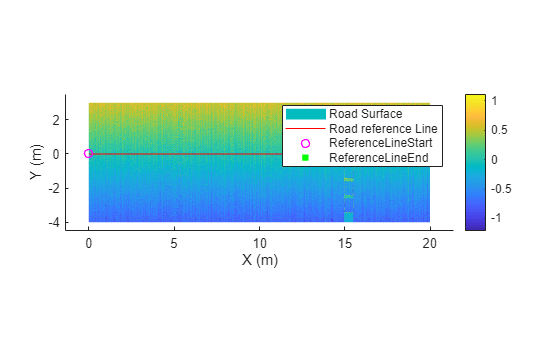
Create a road surface object.

rsObj = roadSurface(ptCld,roadRefLine,roadWidthFromRefLine,gridResolution)
rsObj = 
  roadSurface with properties:

         RoadReferenceLine: [6×2 double]
         LateralResolution: 0.0100
    LongitudinalResolution: 0.0100
      RoadWidthFromRefLine: [4 3]
       InterpolationMethod: "nearest"
       ExtrapolationMethod: "nearest"
               LocalOrigin: []
    HasNormalizedElevation: 1

Visualize the road surface.

show(rsObj)

Load point cloud data and a road reference line.

Note: The point cloud data must contain the road information for the specified road reference line.

data = load("roadSurfaceData.mat","ptCld","roadRefLine");
ptCld = data.ptCld;
roadRefLine = data.roadRefLine;

Specify the width of the road from reference line as 4 meters from left and 3 meters from right.

roadWidthFromRefLine = [4 3];

Specify the resolution of the road surface as 1 cm in each longitudinal and lateral direction.

gridResolution = [0.01 0.01];

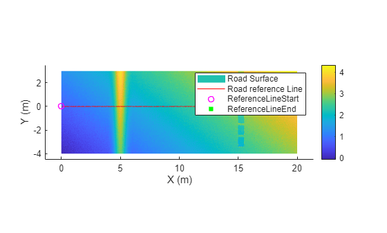
Create a road surface object without normalized elevation.

rsObj = roadSurface(ptCld,roadRefLine,roadWidthFromRefLine,gridResolution,NormalizeElevation=false)
rsObj = 
  roadSurface with properties:

         RoadReferenceLine: [6×2 double]
         LateralResolution: 0.0100
    LongitudinalResolution: 0.0100
      RoadWidthFromRefLine: [4 3]
       InterpolationMethod: "nearest"
       ExtrapolationMethod: "nearest"
               LocalOrigin: []
    HasNormalizedElevation: 0

Visualize the road surface.

show(rsObj)

Version History

Introduced in R2025b