What Is Satellite Communications?
Satellite communications is the process by which radio frequency (RF) signals are sent to and from satellites orbiting the Earth, to enable communication between distant points on the globe. The high frequency radio waves used for communication links travel by line of sight, and so are obstructed by the curvature of the Earth. The purpose of communication satellites is to relay and amplify these signal, using a transponder around the curve of the Earth enabling communication between widely separated geographical points. The communication can be one-way, such as television broadcast satellites, or two-way, such as satellites that carry internet traffic, telephony, radio communications, and navigation signals. This block diagram shows a simple unidirectional communication between Earth stations and a satellite. Bidirectional satellite communication and cross-link, where two satellites communicate with each other, are similar to this process.

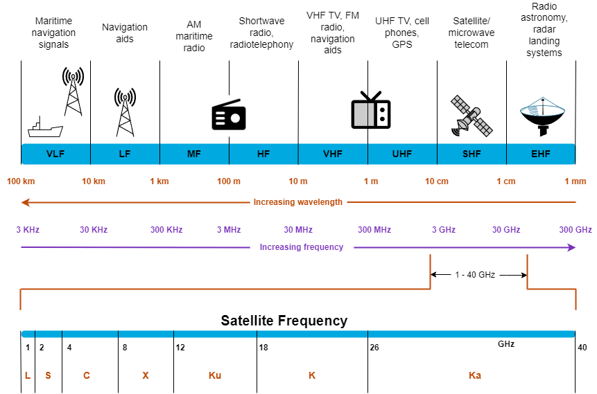
Frequency Bands
Satellite communications occur over a wide range of frequency bands, from 137 MHz for mobile-satellite service to 18 GHz for satellite television. The higher frequency bands typically give access to wider bandwidths, but are also more susceptible to signal degradation due to various atmospheric factors.
This diagram shows the RF frequencies and the satellite frequency bands available for use.
Satellite Orbits
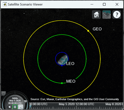
Communication satellites usually have one of these primary orbit types.
Geostationary Earth Orbit (GEO) — This circular orbit is 35,785 km from the Earth surface.
For many years, satellite communication systems were implemented with GEO orbits. The apparent position of a GEO satellite in the sky, when viewed by an observer on Earth, does not change because it orbits the Earth at the same angular speed as the Earth rotation, and thus appear stationary in the sky. From their high altitude, satellite communication systems achieve nearly complete Earth coverage using only three satellites, placed 120 degrees apart in longitude.
Applications for GEO satellites include weather forecasting, satellite television, satellite radio, and other types of global communications. However, GEO satellites have long propagation delays, which are problematic for time-sensitive communications.
Medium Earth Orbit (MEO) — This orbit ranges from 2,000 to 36,000 km above the Earth.
MEO satellites have historically been used for Global Positioning System (GPS) and other navigation systems. Approximately 32 satellites in MEO can cover any given spot on the Earth at any time during the day. To determine the position of a point on Earth, four satellites must be visible at the same time from that particular point on the Earth surface.
Low Earth Orbit (LEO) — This orbit ranges from 160 to 2,000 km above the Earth.
In recent years, multiple communication providers have launched constellations of LEO satellites, as they have much smaller propagation delays and are better suited for time-sensitive applications. For example, if a GEO satellite requires 0.25 seconds for a round trip, then an MEO satellite requires less than 0.1 seconds, and an LEO satellite requires only 0.05 seconds to complete the same trip. However, a single LEO satellite covers a much smaller area than a GEO satellite, requiring many LEO satellites to achieve the same coverage.
LEO satellite applications include transmissions that are real-time and tolerate low delays, such as communication, signal monitoring, and scientific research (Earth observation satellites, the International Space Station, Hubble Space telescope).
Model and Visualize Satellite Environment
To help you understand a satellite environment, irrespective of the orbit type,
Satellite Communications
Toolbox has the satelliteScenario
object which enables you to perform these tasks.
Model a satellite scenario, including satellites, ground stations, transmitters, receivers, gimbals, and antennas.
Perform visibility analyses and communications link analyses.
Visualize the entire satellite scenario and the field of view, in both 2-D and 3-D.
Link Budget Analysis
Link budget calculations utilize power budget analysis, and establish an approximate level of performance, without resorting to link-level simulation. Link budget establishes the system parameters necessary to ensure that the information is received intelligibly with an adequate signal-to-noise ratio.
Satellite link budget analysis accounts for all the power gains and losses that an RF signal experiences, from a transmitter, through the communication medium, to the receiver. Various factors influence the link design, including antenna design and size, power amplifier output, rain margin, free space path loss, system availability, antenna pointing loss, and polarization losses.
This is a simple link budget equation, to help design a proper link.
Received power (dBm) = modulated output power (dBm) + high power amplifier gain (dB) + antenna gain (dB) – free space path loss (dB), where:
Power levels are expressed in dBm
Power gains and losses are expressed in decibels (dB)
Satellite Communications Toolbox includes these tools for performing link budget analysis.
Satellite Link Budget Analyzer — Use this app to perform a static analysis of a detailed link budget. The app enables you to customize all parameters and visualize results for sensitivity analysis. You can also perform availability analysis using this app.
satelliteScenario— This object has the functionality to perform dynamic link budget analysis.
Link-Level Simulation
An essential part of satellite communications development involves generating standards-based waveforms and building their transceivers. Satellite communications transceiver design requires access to standards-based waveforms. These standards include:
Digital Video Broadcasting Satellite Second Generation (DVB-S2)
This is a physical layer standard that supports high data-rate satellite communications. It provides specifications for framing structure, channel coding, modulation systems, and spectrum efficiency. The DVB-S2 standard supports a wide range of applications, such as news-gathering from remote locations, high-definition television (HDTV) broadcast services, internet access, cellular backhauling, and government and defense networks.
The DVB-S2 standard supports QPSK, 8PSK, 16APSK, and 32APSK modulation schemes and 28 combinations of modulation and code rates (MODCODs).
Digital Video Broadcasting Satellite Second Generation extended (DVB-S2X)
This is a physical layer standard that is an extension of DVB-S2. DVB-S2X enhances the support provided for core DVB-S2 applications and improves overall efficiency of communication through satellite links. The primary difference between DVB-S2 and DVB-S2X is that the DVB-S2X adds more features and capabilities in signal processing, resulting in higher efficiency and better receiver performance, enabling high-throughput satellite (HTS) applications.
In addition to the capabilities supported by DVB-S2, the DVB-S2X standard also supports higher-order modulation schemes — 64APSK, 128APSK, and 256APSK, smaller filter roll-off options for better bandwidth utilization, and 116 combinations of MODCODs.
Digital Video Broadcasting Second Generation Return Channel Satellite (DVB-RCS2)
This is a medium access control (MAC) and physical layer standard that provides a return channel to enable internet and other data services over satellites.
GPS and other global navigation satellite system (GNSS) standards
GNSS include constellations of Earth-orbiting satellites that provides positioning, navigation, and timing services on a global or regional basis. Prevalent GNSS standards and the countries who own them include GPS (U.S.), Galileo (Europe), BeiDou (China), Glonass (Russia), NavIc (India), and QZSS (Japan).
GPS is the most widely used GNSS. GPS uses the general technique of code division multiple access (CDMA), which is a spread-spectrum radio technique. There are four GPS signal specifications designed for civilian use: L1 C/A, L2C, L5, and L1C.
Consultative Committee for Space Data Systems (CCSDS) waveforms
The CCSDS family of waveforms includes CCSDS Telemetry (TM), CCSDS Telecommand (TC), and CCSDS optical high photon efficiency (HPE).
Ground stations use CCSDS TC to send commands to a spacecraft, whereas satellites CCSDS TM to transfer data to an Earth station. CCSDS optical HPE communications are useful for applications where power efficiency is the dominant consideration in link design, such as in deep-space communication scenarios.
5G New Radio (NR) non-terrestrial network (NTN)
NTNs are networks or segments of networks that use airborne or spaceborne vehicles for transmission. Integrated satellite-terrestrial solutions can provide ubiquitous 5G service, at a lower cost than terrestrial-only deployments, to places where it is technically difficult or prohibitively expensive to use a terrestrial network.
For examples of how to generate waveforms using the toolbox, see Generate Waveforms.
The 5G standard has incorporated satellite-based NTN platforms to increase global coverage in rural and maritime environments, and to provide communications services during disaster recovery operations. Future plans for the 6G network make heavy use of the NTN systems. For information on how to account for the significant Doppler shift created by the LEO satellites used in an NTN, see the NR NTN PDSCH Throughput example.
With multiple companies launching thousands of LEO satellites into orbit, and with the need for those LEO satellites to relay data to one another to complete links between distant points on Earth, the risk of inter-satellite interference is significant. To reduce this risk, many satellite communications service providers are turning to optical cross-links because of their extremely narrow beamwidths. Modeling optical links requires new capabilities beyond RF link modeling. The CCSDS High Photon Efficiency Telemetry Optical Link Simulation example models a CCSDS high photon efficiency (HPE) TM serially concatenated pulse position modulation (SCPPM) optical link.
The toolbox also includes transceivers for these various standards-based waveforms. These examples simulate practical receivers for common satellite communications standards.