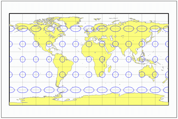
eqdcylin
Equidistant Cylindrical Projection
Classification
Cylindrical
Identifier
eqdcylin
Graticule
Meridians: Equally spaced straight parallel lines more than half as long as the Equator.
Parallels: Equally spaced straight parallel lines, perpendicular to and having wider spacing than the meridians.
Poles: Straight lines equal in length to the Equator.
Symmetry: About any meridian or the Equator.
Features
This is a projection onto a cylinder secant at the standard parallels. Distortion of both shape and area increase with distance from the standard parallels. Scale is true along all meridians (i.e., it is equidistant) and the standard parallels and is constant along any parallel and along the parallel of opposite sign.
Parallels
For cylindrical projections, only one standard parallel is specified. The other standard parallel is the same latitude with the opposite sign. For this projection, any latitude can be chosen; the default is arbitrarily set to 30º.
Remarks
This projection was first used by Marinus of Tyre about A.D. 100. Special forms of this projection are the Plate Carrée, with a standard parallel at 0º, and the Gall Isographic, with standard parallels at 45ºN and S. Other names for this projection include Equirectangular, Rectangular, Projection of Marinus, La Carte Parallélogrammatique, and Die Rechteckige Plattkarte.
By default, the standard parallels are at +/- 30 degrees in geodetic latitude.
When projecting a sphere, the origin vector is used to specify a triaxial rigid-body rotation.
When projecting an ellipsoid:
The origin longitude (2nd element of the origin vector) determines which meridian maps to the line x == false easting
The origin latitude (1st element of the origin vector) is used to shift the natural origin off the equator via a constant y-offset, in addition to any false northing that may be specified.
The grid convergence is fixed at 0, even if the 3rd element of the origin vector is nonzero.
Mapping Toolbox™ uses a different implementation of the equidistant cylindrical projection for displaying coordinates on
axesm-based maps than for projecting coordinates using theprojfwdorprojinvfunction. These implementations may produce differing results.
Example
landareas = shaperead('landareas.shp','UseGeoCoords',true);
axesm ('eqdcylin', 'Frame', 'on', 'Grid', 'on');
geoshow(landareas,'FaceColor',[1 1 .5],'EdgeColor',[.6 .6 .6]);
tissot;
Version History
Introduced before R2006a