Find Ellipsoidal Height from Orthometric Height
R2026bThe height of a point might refer to its ellipsoidal height or its
orthometric height. Mapping Toolbox™ functions such as geodetic2enu require the inputs to specify
ellipsoidal height, but data often quantifies orthometric height instead.
This topic defines ellipsoidal, geoid, and orthometric heights, and shows how to convert orthometric heights to ellipsoidal heights by using a geoid height model.
Ellipsoidal, Geoid, and Orthometric Heights
To convert orthometric height to ellipsoidal height, you can use a geoid height model.
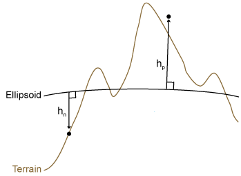
Ellipsoidal height, called h, is height measured along a normal of a reference ellipsoid. For more information about reference ellipsoids, see Comparison of Reference Spheroids. This image shows a positive ellipsoidal height, hp, and a negative ellipsoidal height, hn.
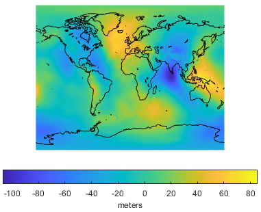
Geoid height, called N, is the height of the geoid measured along a normal of a reference ellipsoid. The geoid models the average sea level of the Earth without effects such as weather, tides, or land. A geoid model is created by measuring variations in the gravitational field of the Earth, so it has a smoothly undulating shape.
For example, geoid height values from the Earth Gravitational Model of 1996 (EGM96) are referenced to the ellipsoid defined by the World Geodetic System of 1984 (WGS84). This illustration of the geoid from EGM96 shows geoid heights in meters.
Orthometric height, called H, is height above the geoid. Most terrain models provide data using orthometric height instead of ellipsoidal height.
This image shows the relationship between ellipsoidal height, orthometric height, and the geoid. The values h1, H1, and N1 demonstrate the relationship for an airborne point, while h2, H2, and N2 demonstrate the relationship for a point on land.
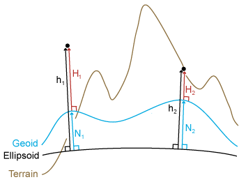
To approximate the ellipsoidal height of a point, you can add the orthometric height to
the geoid height: h = H +
N. You can find the height of the geoid from EGM96 at specified latitudes
and longitudes by using the egm96geoid function.
Note that the sum of orthometric and geoid height is an approximation of the ellipsoidal height because the direction along which a geoid height is measured is not necessarily the same as the direction along which an orthometric height is measured. However, this approximation is suitable for most practical purposes.
Find Ellipsoidal Heights from Orthometric and Geoid Heights
Calculate the ellipsoidal heights of several points from their orthometric heights and a geoid model. Specify the height reference for the points using a 3-D coordinate reference system (CRS).
Calculate Ellipsoidal Heights
Read elevation data from a DTED file into the workspace as an array and a raster reference object. Prepare to combine the elevation data with the geoid model by returning values of type double.
[H,RH] = readgeoraster("n39_w106_3arc_v2.dt1",OutputType="double");
Query the vertical CRS for the elevation data. The result indicates that the elevations are orthometric heights in meters.
RH.GeographicCRS.VerticalCRS
ans =
  vertcrs with properties:

          Name: "EGM96 height"
         Datum: "EGM96 geoid"
     Direction: "up"
    LengthUnit: "meter"
The raster reference object associates the elevations with latitude and longitude coordinates. Query geoid heights for the same locations by using the egm96geoid function.
N = egm96geoid(RH);
Calculate the ellipsoidal heights of the locations by adding the orthometric heights to the corresponding geoid heights.
h = H + N;
Specify 3-D CRS for Ellipsoidal Heights
Create a raster reference object for the ellipsoidal heights by copying the original reference object and updating its CRS. Replace the geographic CRS with the 3-D geographic CRS for WGS84, which has the EPSG code 4979.
Rh = RH;
crs3d = geocrs(4979);
Rh.GeographicCRS = crs3d;
View the height reference for the ellipsoidal heights by querying the vertical CRS.
Rh.GeographicCRS.VerticalCRS
ans =
  vertcrs with properties:

          Name: "WGS 84"
         Datum: "World Geodetic System 1984 ellipsoid"
     Direction: "up"
    LengthUnit: "meter"
The elevation data used in this example is from the US Geological Survey.
References
[1] NOAA. "What Is the Geoid?" National Ocean Service website. https://oceanservice.noaa.gov/facts/geoid.html, accessed on June 25, 2018.
See Also
egm96geoid | geodetic2enu | geocrsvertcrs

